
Signs of oil drilling emerge, in little skylines of storage tanks along the highway, along with the occasional slowly churning derrick. A lone shack leans at an unwieldy angle, its plank walls nearing collapse. This was a hard place to live, a terrain humans cannot fully conquer. Even so, no one would dare call anyone “soft” for living on these gruff plains. We crossed several little towns, some no more than a few leaning structures harassed by unsparing wind.
Not until Ault would be encounter signs of prosperity. Houses clustered together in several communities, previous homes left to rot among rusting farm equipment. Created to prevent another dust bowl, the grassland spans much of the 100 miles between Sterling and Fort Collins. Through a few creeks and springs, wildlife is abundant through the rolling savannah. Deeper in the grassland stand the Pawnee Buttes, a pair of 300-foot tall mesas, the sole markers of higher elevation plains that eroded across thousands of millennia. Here nothing rises taller than the stick figures of electric transmission towers, dozens bent in the same awkward posture clear to the horizon.
After Ault, the Rocky Mountains’ Front Range inches free of the morning haze. The yards greened, even one where a water buffalo grazed (or some other large, horned bovine misplaced in split-railed yard). The endless strip malls and grinding construction blurred together, breaking as we reached the Devil’s Backbone rock formations west of Loveland, a landmark on the route to Rocky Mountain National Park.
 |
| Big Thompson Canyon walls |
Without horses, our cars followed narrow highway through the steep, boulder-strewn canyon and its frequent morning signs about scrambling to high ground if rain engorges the Big Thompson River. The Big Thompson River originates in Forest Canyon, near the eastern edge of the nation park. At Estes Park, a dam forms Estes Lake.
Not far from its shore, we stopped at Hunter’s Chophouse for Mr.Todd’s birthday dinner. Most of us picked burgers and steak from Rocky Mountain game meats, the restaurant’s specialty. Lunch breezed by, although the mounted head of a massive bull elk stared at me during the entire meal.
Estes Parks feels the pull of separate destinies. As the gateway to Rocky Mountain National Park, the town has elements of a tourist trap as well as blocks of a hip mountain enclave. You can find water parks around one turn, and boutique shops around another. Maybe that’s why Estes Park succeeds – as a small town, it can still be the destination anyone desires, and never drops to the kitschy lows of other tourist traps near natural curiosities. Longs Peaks the park’s premier 14’er, reveals itself among the peaks hiding the Rocky Mountain interior. A few turns and our trip into the mountain peaks began.
At the national park guard shack, as Nancy handed her dad’s ID and senior pass to the ranger, he only asked if we needed a map, glancing at the senior pass and not acknowledging the birthday visit to keep the line moving. I noticed the elk absent from the picket fence near the station and the Moraine Creek Visitor Center. Initially we thought a birthday celebration with a pie from Estes Park shop would fit with Bear Lake, but the heavily visited spot already reached capacity. Instead we opted for vistas and elevation.
All road discussion in Rocky Mountain National Park inevitably arrives at Trail Ridge Road. The world’s highest continually paved highway spans 48 miles between Estes Park and Grand Lake, exceeding elevations of 12,000 feet in spots, twisting and curving to provide panoramic views of the park’s many ranges. In its first miles from Este Park, Trail Ridge Road climbs through montane, subalpine pine forests and tundra ecosystems.
The patches of aspens we spotted began to turn yellow, the short season draining their greens and pushing them into dormancy. We observed similar patterns in South Park two years earlier, where the aspens served as the clarion call for the end of the season. At the Many Parks Curve, photographers with tripods blocked easy views of the mountains, some of the best vantage points along Trail Ridge Road.
We plowed ahead, the rises growing more familiar. Two miles above sea level, the disappearance of tree grew inevitable. Trees that endured grew gnarled. Banner trees, which only sprouted branches on one side due to constant wind, came to dominate the roadside.
Winds blew constantly but not harshly at Rainbow Curve, where we stopped to soak in the alpine views. The Fall River and its eponymous road swung around bends more than 2,000 feet below us. The patchy, swift clouds played tricks with the sunlight above Rocky Mountain National Park’s valleys. The beauty escaped description. We could view rows of mountains and broad valleys cut by the curves of Trail Ridge Road.
 The same chipmunks I remembered from nine years earlier scampered along the rocks below the barrier. Generations of chipmunks knew how to exploit national park visitors, and at this point, the ability probably dwelled within their DNA.
 Above the tree line, some vegetation, mostly scrubby grasses, still grew. Dense grasses covered the mountainsides, the early winter not yet freezing these heights into barren wastelands. Marmots native to these heights never appeared, although the landscape likely hid their furry torsos better in mid-September.
 Other wildlife presented itself. From our open window we heard an unmistakable “bah” as we crossed from the piney forests into the scrubby lands above the tree line. We could only conclude that as we passed that spot, a steep decline into a glacial cirque, a bighorn sheep bellowed. None of us saw the sheep, but no other animal could have released such a call.
A few snow flurries fell as we neared Forest Canyon, where springs and creeks formed the headwaters of the Big Thompson River.
Other wildlife presented itself. From our open window we heard an unmistakable “bah” as we crossed from the piney forests into the scrubby lands above the tree line. We could only conclude that as we passed that spot, a steep decline into a glacial cirque, a bighorn sheep bellowed. None of us saw the sheep, but no other animal could have released such a call.
A few snow flurries fell as we neared Forest Canyon, where springs and creeks formed the headwaters of the Big Thompson River.The landscape bloomed with brief vegetation and appeared less desolate than my brief 2008 visit. Trail Ridge Road twisted into higher roads, where the grasses turned orange and the road curled beneath steeper cliffs. Above 12,000 feet, a slight headache emerged. Actually we passed the 12,000-foot mark before I realized it, crossing the road’s high point before we decided to turn back. A few miles shy of the Alpine Visitor Center, we stopped at Lava Cliffs before descending.
 At Lava Cliffs, where the rocks differed from the rest of the mountain geology, the temperature slid into the low 40s and the unflinching wind howled. Every step required a struggle against the gusts. I felt as if I might tumbled over the barrier if I tempted these winds too much.
Below the knee-high guardrail, Lava Cliffs overlooked a milky blue lake rimmed in crusty glacial ice, likely the lake Mr. Todd described as having icebergs bobbing in its waters during the summer. As fall intruded, the lake seemed primed for the ridges of ice swallow the turquoise waters again.
At Lava Cliffs, where the rocks differed from the rest of the mountain geology, the temperature slid into the low 40s and the unflinching wind howled. Every step required a struggle against the gusts. I felt as if I might tumbled over the barrier if I tempted these winds too much.
Below the knee-high guardrail, Lava Cliffs overlooked a milky blue lake rimmed in crusty glacial ice, likely the lake Mr. Todd described as having icebergs bobbing in its waters during the summer. As fall intruded, the lake seemed primed for the ridges of ice swallow the turquoise waters again.From there we descended, drifting snow thankfully absent from the road as we twisted toward more amenable altitudes and back into the grasp of changing aspen leaves. In a few short miles we reached more comfortable altitudes, where the slightest breeze did not slice through clothing better suited to valley bottoms.

Around one more corner, we saw his destination, a trio of cow elk lounging by a pool on the Fall River. The bull elk moved into view faster than expected, congregating with the cows by the stream. As tourons surged toward the huge ungulates, an NPS ranger warned them back. “We got in trouble,” one of them said laughingly as he walked back. It made me wish he could have faced down the bull elk, which might have muted the laughter.

As the bull arrived, the young males didn't flee but watched the bull's every move. As he grazed within 20 feet, they rose and stepped away slowly. The spikes gave the massive bull all the space he wanted to graze, his spot in the pecking order assured.

What amazed me was how closely this second jaunt to Rocky Mountain National Park hewed to my first. In a few short hours we drove above the tree line on Trail Ridge Road and glimpsed the elk rut. Nancy and I might have to move to Colorado to hike deeper into those enormous tracts of wilderness in search of wildlife not easily seen from the road (moose, marmots, black bears).
A couple of turns through Estes Park and its reservoir dropped us into the soaring walls and boulder-covered floodplains of Big Thompson Canyon.


A wave of water killed 144 people, five never recovered. Although freak storms that dump enough rainfall to equal the area’s annual average are rarities, evidence of the 2013 flood still arises all across the canyon. In a few hours, the briskly flowing waters can turn deadly. Signs that warn motorists to move to higher elevation in event of flooding speak to a lesson learned painfully.
More yellow signs warned of wildlife. A “watch for wildlife” zone encompasses the entirety of Estes Park and Big Thompson Canyon. After the elk, I expected little until we reached the flatlands and spotted more hungry hawks on the telephone wires.
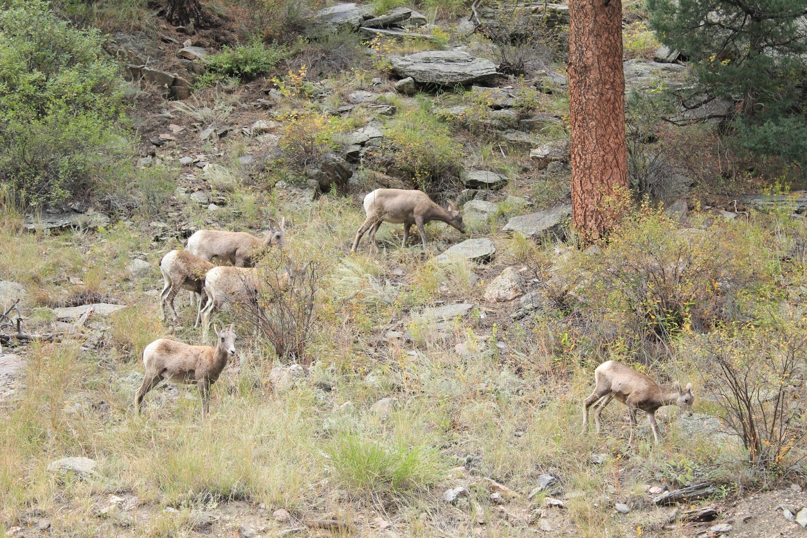
Then Nancy pointed and motioned for me to look. I had no idea what to look for. Around a soft bend with a pulloff and easy river access, cars slowed rapidly. We joined an old-fashioned wildlife jam. Nancy pointed to the canyon wall as my eyes struggled to focus. But there they were. My eyes adjusted and spotted several creatures grazing in perfect camouflage among the canyon foliage.
The largest of the eight bighorn sheep stood on the road apron, seemingly ready to lead the others across the safety. As long as the cars linger, the sheep eyed them warily. This little herd was all females and young sheep; no rams with their massive curled horns appeared in the canyon. The eight sheep stood on a hillside that rose with an intimidating grade, no challenge for a species that can inch along walls that rise almost vertically.
As we moved on, the sheep stayed patient, biding their time till they could safely cross the pavement and drink from the Big Thompson.

No comments:
Post a Comment