 |
| Eastern Washington |
 |
| Columbia River Gorge |
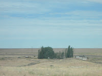
Either side of the river the terrain is rough scabland, scoured clean by glacial lake flooding at the end of the last Ice Age. As the land flattens, it grows greener and crops and pale grasses, although sagebrush garnishes what hills remain. Few cities and fewer trees dot the horizon.
As the land reached its flattest moments, new stands of pines sprouted close to Spokane. The collapse of Glacial Lake Missoula during the last Ice Age scrubbed this landscape. I never spent so many miles as a passenger across the West – 681, to be exact. My sister picked me up at Seatac, then we immediately turned east to Snoqualmie Pass and the road pinned to the banks of exquisite Rimrock Lake. The vegetation gradually shed the Sitka spruce and Douglas firs that dominate the coastal Northwest.
 |
| Downtown Spokane |
Any trees were at a premium around eastern Washington, fields of corn, potatoes and alfalfa rolling to the horizon. In Idaho and Montana, the pines resumed dominance but became leaner and paler greener without shedding any majesty. The mountains and river valleys grew more ragged than the young, verdant Cascades. Spokane looms close when the pines intrude on the rolling green and tanned plains. Washington’s other metropolis charged into view with a downtown of eye-catching vintage brick buildings – before fading into the usual detritus of suburban shopping. We were ready for Idaho’s remote finger.
Fortunately, it was just down the road. Once Spokane’s stately downtown and strip-mall outskirts pass, you will rarely travel unaccompanied by water. Coeur D’Alene Lake fills a valley below the road. Other glacial-carved lakes lie throughout the Panhandle and western Montana, shimmering blue waters angles to pristine depths. On the return trip the flatness won’t strike as hard as the sudden monuments of sadness – in Post Falls and across Spokane flags flew at half-mast to remember the people massacred at an Orlando nightclub.
 |
| Lake Coeur s'Alene |
 |
| Wallace from the window |
None stood out more than Wallace, the town scorched during the Big Burn of 1910. The great fire wiped out half the town, but the historic district coursed with architectural ingenuity. So did the highway, which curved around the town as a concession to the last traffic lights on I-90 before the whole 3,000-mile route became restricted-access highway.
Construction slowed us briefly on a wavy, scenic section of interstate rising to Lookout Pass at the Montana border. The road at Lookout Pass feels perilous and dreamlike, as if the highway hangs above the valley below. The descent is muted across Montana, but the St. Regis River begins there, its current widening until reaching its namesake town and collides with the Clark Fork of the Columbia.
 |
| A colorful western Montana peak |
Were it less beautiful, the Clark Fork might grow annoying. Across western Montana, its highway crossings number in the dozens. I could never tire of so frenetic a river. As the daylight reach the golden hour reds and purples erupted from rock faces along the road. Give nature enough time on a sunny day, and it will supply a light show. Around sunset, our crossings of the Clark Fork reach the five mountain valleys that meet at Missoula.
 |
| Blurry shot of the Clark Fork |
The air cooled considerably as the sun escaped. Bugs pummeled my sister’s car, making our stop more necessary to clean the windows than to gas up. By nightfall, we were accompanied only by a deep field of stars, a fingernail moon and the crimson glow of Mars. Around Anaconda, a yellow glow illuminated the base of the Anaconda Stack, the brick chimney memorializing the smelting operations that gave rise to the town. At Butte, the mountain ridges were invisible but for the chaste glow of Our Lady of the Rockies, a massive statue of the Virgin Mary.
A day of travel demanded a heavy toll of sleep. Between airlines and I-90, I essentially formed a massive ‘J’ across the western states (Nashville to San Diego, San Diego to Seattle, Seattle to Spokane to Missoula to Bozeman). Not the most efficient route, but despite numerous changes to travel plans we ended up where we intended.
At this point, I was approaching 20 years without more than a wisp of sleep. Most of the ride between the Continental Divide and Manhattan was lost to me. I shook off sleep as we entered Belgrade then the outskirts of Bozeman. A gruff-toned but affable night attendant checked us in. It was time a for a beer, thanks to a Town Pump near Missoula, we had some options. I went with The Juice Double IPA from Madison River, the first craft brewery I spotted after landing in Bozeman back in 2009. But not even its heavy dose of hops could further stall sleep.
Morning arrived too soon but at least the lush green Bridge Mountains hid behind the curtain. We had a big breakfast at Main Street Overeasy, a Bozeman staple, then plotted a trip back out of the Gallatin Valley. The shortest of stays in Bozeman always has its moments, even after the epic drive that led there.
 |
| Worth every view like this. |
No comments:
Post a Comment